
Automate’s road network feature allows you to extract road network data within a user-defined area using OpenStreetMap (OSM) under the Open Database License. This guide explains how to generate a KML file and select road types for extraction.
Step-by-Step Instructions
-
Draw Your Area of Interest
-
Use the polygon tool to select the region for road network extraction.
-
-
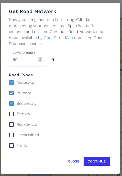
Set Buffer Distance
-
Specify a buffer distance (e.g.,
60 ft) to expand the search around your drawn area.
-
-
Select Road Types
-
Check/uncheck the road types you wish to include in your export:
-
|
Road Type |
Description |
OSM Documentation |
|---|---|---|
|
Motorway |
High-speed, restricted-access highways (e.g., freeways). |
|
|
Primary |
Major roads connecting large towns/cities. |
|
|
Secondary |
Important roads, but less critical than primary. |
|
|
Tertiary |
Roads linking smaller settlements or local centers. |
|
|
Residential |
Roads in housing areas with low speed limits. |
|
|
Unclassified |
Minor public roads, often rural. |
|
|
Trunk |
Key non-motorway highways (e.g., national routes). |
-
Generate KML File
-
Click Continue to create a line-string KML file of the selected road network.
What is the buffer distance?
The buffer extends the search beyond your drawn polygon (e.g., 60 ft ensures roads near the edges are included).
Which road types should I select?
-
For urban areas: Prioritize Primary, Secondary, Tertiary, Residential.
-
For highways: Include Motorway and Trunk.
-
For rural areas: Add Unclassified.
Data License
Data is sourced from OpenStreetMap and is available under the Open Database License (ODbL).