
Additional Deliverables
In addition to our standard deliverables, AirWorks also offer a selection of add-on deliverable file formats, all of which can be added to a project at the time you place an order. After you select your bundle and add-on layers, you will be able to manually select one or more of the different deliverable types listed below.
These add-ons are assessed as additional acres to your processing area and will result in a larger "Charged Acres" figure. This allows your team to process an order, with add-ons, without needing to pay for each additional layer at the time of checkout.
List of add-on deliverables:
Landxml File Format | |
|---|---|
Description | Receive a .landxml surface file in addition to other standard deliverables. |
Geojson File Format | |
|---|---|
Description | Receive a Geojson file (.geojson) in addition to other standard deliverables. |
Esri File Format | |
|---|---|
Description | Receive an Esri ShapeFile (.shp) in addition to other standard deliverables. |
AutoCAD File Format | |
|---|---|
Description | Receive a .dwg CAD file in addition to the standard .dxf CAD file. |
Bentley File Format | |
|---|---|
Description | Receive a .dgn CAD file in addition to the standard .dxf CAD file. |
Geodatabase File Format | |
|---|---|
Description | Receive a .gdb geodatabase file in addition to other standard deliverables. |
Contours from Breaklines (016) | |
|---|---|
Description | Contours (layers G-TOPO-MAJR and G-TOPO-MINR) will be built from ground segmented point cloud and breaklines (a line used to control triangulation and surface geometries at an inflection point or a sharp elevation change). |
Input Data Format | BOTH .tif and .las |
Input data quality requirements | 1’/5′ (minor/major) 2’/10′ (minor/major) |
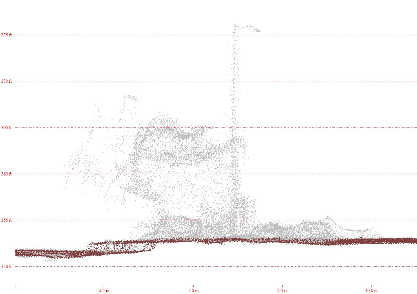
Classified Point Cloud (017) | (Ground, Non-ground) |
|---|---|
| Ground segmented point cloud delivered as a separate .las file. All points are assigned either ground or non-ground classification only. Non-ground classified points can include ground points not included in the surface generation. |
|  |
Input Data Format | .las |
| RMSEz – 0.32′ min GSD Source Imagery – 0.32′ min, 0.16′ recommended |
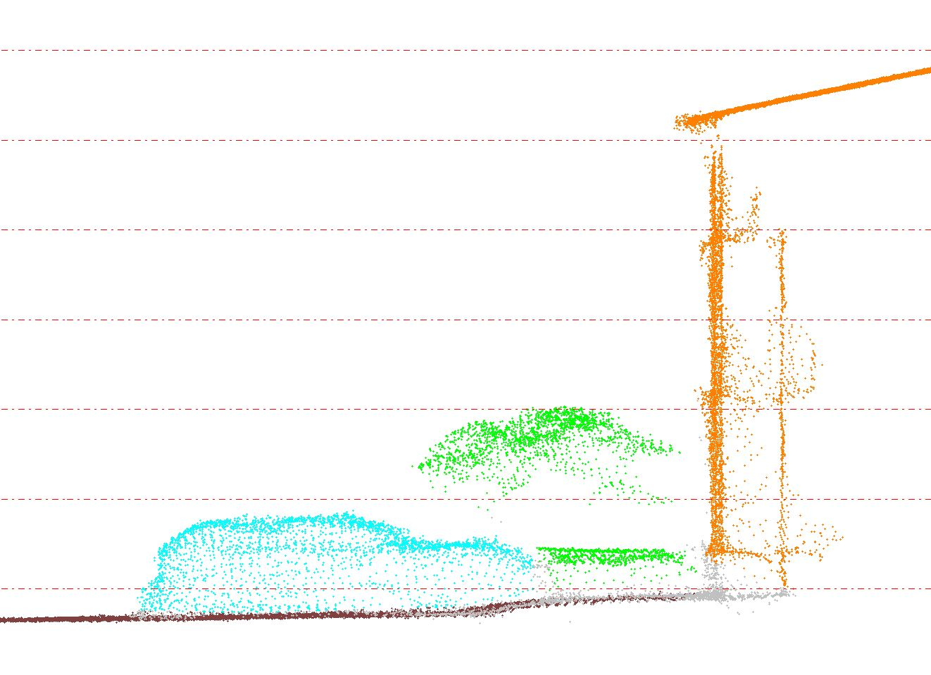
Classified Point Cloud (017) | (Ground, Non-ground, Buildings, Cars, Vegetation, Poles) |
|---|---|
| Ground segmented point cloud delivered as a separate .las file. All points in the point cloud classified in 6 classes: Ground, Non-ground, Buildings, Cars, Vegetation, and Poles. All points within a feature are assigned to their designated class. |
|  |
Input Data Format | .las |
| RMSEz – 0.32′ min GSD Source Imagery – 0.32′ min, 0.16′ recommended |
Obstruction | |
|---|---|
Description | This deliverable will consider such data which are not captured/covered because of obstruction while surveying. Areas Obstructing Ground Segmentation are considered here. |
Breaklines Powered by Datasight | |
|---|---|
Description | Breaklines Powered by Datasight are delivered the same way as your usual AirWorks deliverables – via the project page in your account, where you can choose to view and download the files. For each job processed by BreaklineBuilder, three full sets of output data are calculated with different grade-break sensitivities (Low, Med, High). You will receive all three and given the option to use the one that works best for your project. |
AirWorks Breaklines | |
|---|---|
Description | |