
Accepted File Formats
AirWorks accepts the following files:
Orthomosaic Images
.tif and .tiff files only (we accept .tiff files as of July 2022)
0.01 < GSD < 0.25 feet.
GSD< 0.05’ feet for survey-grade (1/10 ft.) accuracy
Must be georeferenced to a recognized coordinate system (meaning it contains an EPSG code).
Minimal distortions.
If your data does not meet the minimum GSD threshold, you will receive the following warning in our app (you may proceed past this if you do not require a highly accurate deliverable)
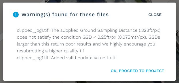
GSD warning in AirWorks app.
Point Clouds
Multiple versions of .las and .laz are accepted.
Point cloud density (PCD) should be above 400 points per square meter unless LiDAR has been used.
PCD ideally above 800 points per sqm
If LiDAR has been used, the space between points should be less than 1 ft in both columns and rows.
Ideally, the space between points should be less than 6”
Boundary Files
The AirWorks web-app allows you to draw the boundary of the site area that you would like processed. Doing this in the app reduces misalignment issues.
However, if you already have a boundary file and would like to upload it, we accept:
.kml files
The file should be a single feature boundary, fully enclosed.
As of July 2022, we also accept a linestream type KML but you will be prompted to add a buffer no smaller than 35 feet to it.